
خدماتنا
خدماتنا
تقدم الشركة مجموعة شاملة من خدمات الهندسة المساحية والچيومكانية، تشمل
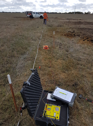
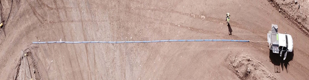
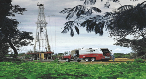
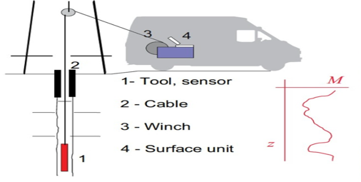
Geophysical Survey Department
Geophysical Survey Department at Specialized Expertise offers advanced solutions subsurface
investigations using geophysical techniques. These services support infrastructure projects.
Seismic methods
Electrical methods
Well Logging
قسم المسح الجيوفيزيائي
يقدم قسم المسح الجيوفيزيائي في الخبره المتخصصة حلولاً متقدمة للتحقيقات تحت السطحية باستخدام التقنيات الجيوفيزيائية
.تدعم هذه الخدمات مشاريع البنية التحتية.
الطرق الكهرومغناطيسية
الطرق الكهربائية
الطرق الزلزالية
تسجيل الآبار
نحن نقدم مجموعة كاملة من خدمات المسح المتقدمة.
بخبرتنا المتخصصة، نقدّم طيفًا واسعًا من خدمات المسح والجغرافيا الهندسية التي تم تصميمها من أجل الدقة والسرعة والأمثال – لتمكين مشاريع البنية التحتية، والتخطيط العمراني، والزراعة، والطاقة في المملكة العربية السعودية.
يجمع فريقنا بين الخبرة الميدانية والتقنيات المتقدمة بما في ذلك المسح باستخدام الطائرات بدون طيار (UAV)، والمسح بالليدار (LiDAR)، والمسح بالليزر ثلاثي الأبعاد، والرادار المخترق للأرض (GPR)، وتطوير قواعد البيانات الجغرافية (GIS).
ومنهجية التضاريس الرقمية – جميعها تتم وفقًا لأعلى المعايير المهنية.
نحن نتجاوز جمع البيانات، نحو تحويل مجموعات البيانات الجغرافية المعقدة إلى نتائج قابلة للتنفيذ وذكية تتماشى مع أهداف رؤية 2030 للاستدامة والتحول الرقمي.

- What We Do
End-to-End Surveying Services.
That Match Project ComplexityOur multi-disciplinary expertise spans all critical dimensions of surveying and spatial data processing
Lorem ipsum dolor sit amet, consectetur adipiscing elit, sed do eiusmod tempor incididunt ut labore et dolore magna aliqua. Ut enim ad minim veniam, quis nostrud exercitation.
Lorem ipsum dolor sit amet, consectetur adipiscing elit, sed do eiusmod tempor incididunt ut labore et dolore magna aliqua. Ut enim ad minim veniam, quis nostrud exercitation.
Lorem ipsum dolor sit amet, consectetur adipiscing elit, sed do eiusmod tempor incididunt ut labore et dolore magna aliqua. Ut enim ad minim veniam, quis nostrud exercitation.
Lorem ipsum dolor sit amet, consectetur adipiscing elit, sed do eiusmod tempor incididunt ut labore et dolore magna aliqua. Ut enim ad minim veniam, quis nostrud exercitation.
Our Featured Frequently Asked Question.
Lorem ipsum dolor sit amet, consectetur adipiscing elit. Ut elit tellus, luctus nec ullamcorper mattis.